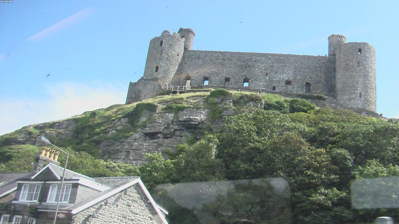
At a glance
Harlech is a small town on the Gwynedd coast defined entirely by its castle — a UNESCO World Heritage fortress on a sea cliff, built 1283–1289, with the most dramatic views of any Iron Ring castle across Tremadog Bay to the Llŷn Peninsula and back to Snowdonia. Harlech Beach is 1.5 miles from the castle across the Morfa plain. Served by the Cambrian Coast Line railway. A natural stopping point on the Cambrian Coast route between Porthmadog and Barmouth.
About Harlech
Harlech's entire historical significance is concentrated in its castle. The town that grew around the fortress is small — a few streets, a handful of shops, a post office, some accommodation — and exists largely in relation to the extraordinary medieval structure that sits above it. This is not a deficiency but a clarity of purpose: Harlech is what it is, and the castle is everything. Visitors who approach expecting a substantial town will be surprised; visitors who come for the castle will be rewarded beyond what any photograph has prepared them for.
The castle's position is its defining characteristic. Built in the 1280s on the same great rock platform that had been a defended site since the Iron Age, Harlech commands a panorama of extraordinary completeness: the bay in front, the mountains behind, the Llŷn Peninsula as a clear landmass to the northwest. When the sea reached the base of the cliff in the medieval period, the castle was virtually impregnable — its water gate provided supply access that made the landward siege almost irrelevant. The seven-year siege of 1461–1468 tested this proposition and found it true: the garrison held longer than any other castle in British history during the Wars of the Roses, and "Men of Harlech" commemorates the fact.
The Rhinog mountains that rise immediately east of Harlech provide a counterpoint to the maritime aspect. These ancient, rocky ridges — pre-Cambrian in geological age and among the oldest landforms in Wales — are walkable from the town but are very different in character from the managed mountain experience of Snowdon. They are wild, navigationally demanding, and rarely crowded. The reward is a solitude and a quality of mountain landscape that even Snowdonia's busiest periods cannot diminish in the Rhinog heartland above the coast.
What to see and do
- Harlech Castle — UNESCO Iron Ring fortress; battlements with panoramic views (Cadw admission).
- Harlech Beach — long sandy beach 1.5 miles from the castle across Morfa Harlech.
- Royal St David's Golf Club — links course on the dunes behind Harlech Beach; one of Wales's great golf courses.
- Rhinog mountains — wild, ancient ridge walks east of the town; solitude and serious terrain for experienced walkers.
- Cambrian Coast Railway — scenic rail route to Porthmadog (20 minutes north) and Barmouth (25 minutes south).
- Shell Island (Mochras) — tidal island and lagoon 5 miles south; diverse beach shells and estuary wildlife.
Getting to Harlech
By rail: Cambrian Coast Line — Porthmadog 20 minutes north, Barmouth 25 minutes south, Machynlleth 1 hour 20 minutes south. Services are limited (typically 4–5 per day in each direction); check timetable in advance.
By road: A496 from Barmouth (10 miles south) or Maentwrog (7 miles north). From Porthmadog: 12 miles south on A496. From Betws-y-Coed or Blaenau Ffestiniog: A470 south to Maentwrog, A496 south.
Parking: Free car park on the B4573 below the castle. The castle and town centre are a short steep walk above.
Find it on the map
Frequently asked questions
Harlech is known for Harlech Castle — the most dramatically sited of Edward I's four Iron Ring fortresses, perched on a rock outcrop 60 metres above what was formerly the sea. The castle is a UNESCO World Heritage Site (Cadw) built between 1283 and 1289. Its concentric design — outer and inner rings of walls with massive corner towers — represents the most developed form of Edwardian castle architecture. The view from the battlements across Tremadog Bay to the Llŷn Peninsula and across the Rhinog mountains to Snowdonia is extraordinary.
When Harlech Castle was built in the 1280s, it stood directly above the sea — its water gate, now accessed by the long flight of steps visible from below, was an active sea entrance allowing supplies to be brought in by boat even under siege. Over subsequent centuries, land reclamation and coastal change created the flat plain (Morfa Harlech) between the castle cliff and the present shoreline. The castle's position, which once gave it maritime supply security, now gives it dramatic views over the reclaimed grassland to the sea beyond.
Harlech has its own station on the Cambrian Coast Line — services run south to Barmouth (25 minutes) and Machynlleth, and north to Porthmadog (20 minutes) and Pwllheli. By road, the A496 connects to Barmouth (10 miles south) and Maentwrog (7 miles north, with connection to the A470). From Porthmadog: A496 south, 12 miles. From Betws-y-Coed: A470 to Maentwrog, A496 south — approximately 25 miles. From Manchester: M56, A55, A470 south via Blaenau, A496 — approximately 130 miles, 2 hours 20 minutes.
Yes. Harlech Beach is a long sandy stretch on Cardigan Bay, approximately 1.5 miles from the castle via Morfa Harlech. The beach is accessible by road and on foot across the Morfa (coastal plain). It is broad, backed by dunes, and relatively uncrowded compared to Barmouth and the Llŷn beaches. The Royal St David's Golf Club, one of the great links courses in Wales, occupies the dune system immediately behind the beach.
The Rhinog mountains immediately east of Harlech are wild, craggy, and much less frequented than Snowdonia proper — the Rhinog Fawr and Rhinog Fach ridge is one of the best mountain days in Wales for experienced walkers seeking solitude. Portmeirion is 12 miles north via Porthmadog. Shell Island (Mochras Lagoon) is 5 miles south — a tidal island with a large caravan site, lagoon, and diverse shell beach. Barmouth is 10 miles south via the Cambrian Coast railway or the A496.
"Men of Harlech" (Rhyfelgyrch Gwŷr Harlech) is a Welsh patriotic march associated with the castle's seven-year siege by Lancastrian forces in the Wars of the Roses (1461–1468) — the longest siege in British history. The song celebrates the garrison's resistance and is one of the most well-known Welsh songs internationally. The castle was later occupied by Owain Glyndŵr as his court in the early 15th century. Both connections give Harlech Castle a particular significance in Welsh historical memory beyond its Iron Ring status.